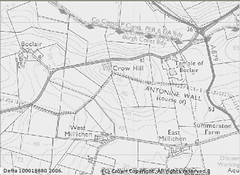
OS Map of Temple of Boclair (courtesy of Magic).
I've discovered a little piece of Magic on the internet.
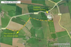
In a previous post, I drew attention to the Antonine Wall at Dobbies Garden Centre. Now, using the UK government's online rural GIS system (snappily entitled Multi Agency Geographic Information for the Countryside, or Magic), you can tap into large-scale Ordnance Survey mapping to analyse any geographical feature: say, the Antonine Wall at Dobbies Garden Centre!
Aerial view of Temple of Boclair
(courtesy of Microsoft's Windows Live Local).
One of my visitors pointed out that all he could see of our premier Roman national monument was "a bumffle in a field". But what an exciting bumfle!
Using the Magic data, you can see that the Antonine Wall (running from west to east) crosses the A879 and turns abruptly SE. Amazingly, on the aerial view (courtesy of the really, really useful Windows Live Local), you can actually see it as it turns and heads off the right-hand side of the photo.
Now don't tell me that's not impressive. Or, in fact, Magic!
"But what an exciting bumfle!"
ReplyDeleteNow I'm being mocked aren't I? :-) Despite your teasing, I stand by my original comments. From ground level (at least from Dobbies) the bumfle is unimpressive. To be honest, I'm not even sure I'm looking at the right place. For someone like myself, with limited imagination and even more limited experience of Roman antiquity, the reconstruction at Dobbies is very helpful. To be fair, it is easy for you - you were there when it was built!
However, the satellite image is impressive. This is fantastic. To be able to see so clearly the evidence of the course of the wall, despite the farming, road building etc. that has gone on, is brilliant. Have you tried a bit of fiddling in photoshop so that the OS map can be overlaid on the satellite image?
For me, I want all three. I'd want to show pupils the satellite and map evidence, then take them to Dobbies to see the reconstruction and then, hopefully, take them into the field to walk along the route of the bumfle ...then it would be an exciting bumfle! :-)
No mockery intended.
ReplyDeleteIt is an exciting bumfle, when you know where to look. And I hope history teachers will use the satellite image in just the way you suggest, before their pupils descend on Dobbies to pillage the juice bar.
However, I fear that the few tourists who will arrive to see our World Heritage Site (en route from the likes of Angkor or Mohenjo-Daro, which are truly impressive relics of the ancient world) (a) won't be able to see the bumfle, and (b) will be singularly unimpressed.
But you will see a bit more at Bar Hill Fort if you manage to find the impressive ditch nearby.... its certainly exhausting to walk up ! And for other impressive site go to Braco Fort on the way to Perth near Stirling - it is a fantastic site to see the ditches around a roman fort - that is if the rabbits havent destroyed it yet - it needs to be preserved - anyone ?
ReplyDelete